
Updating our understanding of Australian frog distributions: Version 4 of the Australian Frog Atlas
From the Alexandria Toadlet to the Yellow-spotted Bell Frog – we’re on the mission to understand where Australia’s 260 frog species are distributed. Version 4 of the Australian Frog Atlas is now released and ready to download, with exciting new updates to our knowledge of frog distributions!
Frogs are one of the most threatened vertebrate groups globally, with 42% of all known species threatened with extinction. The vital first step in knowing how best to conserve species, is knowing where they’re distributed. For frogs, who are generally small-bodied and secretive, this knowledge can be hard to come by, leaving us wondering – where exactly do frogs live?
Atlas of understanding
In 2022, the Australian Museum released the first version of the Australian Frog Atlas – highly detailed distribution maps of all Australian frog species, largely informed by audio recordings of male frog advertisement calls from the Australian Museum’s FrogID project. The quantity of data gathered by people across the country is rapidly increasing each year, with nearly 1.5 million records of frogs now available to improve our knowledge and understanding of frog distributions. So, four years on from the original publication of the Australian Frog Atlas, we’re introducing Version 4 of the Atlas, with an exciting array of new updates, including newly described species, changes to many species’ names, additional data fields, and massive range extensions in some of the most remote parts of the country!
What’s new?
In Version 4 of the Australian Frog Atlas, we’ve updated the known distributions of 76 species. Citizen science data is revolutionising our understanding of biodiversity and species distributions, particularly in remote areas of Western Australia and Queensland. Not only have FrogID users been contributing to improving the spatial sampling coverage of FrogID (nearly 44% of the country covered – check the current spatial sampling map here), but they’ve also revealed that the distribution ranges of the Small Toadlet (Uperoleia minima), Glandular Toadlet (U. glandulosa), and Blacksoil Toadlet (U. trachyderma) are far greater than initially thought, with range extensions of approximately 75km, 40km, and 60km respectively!
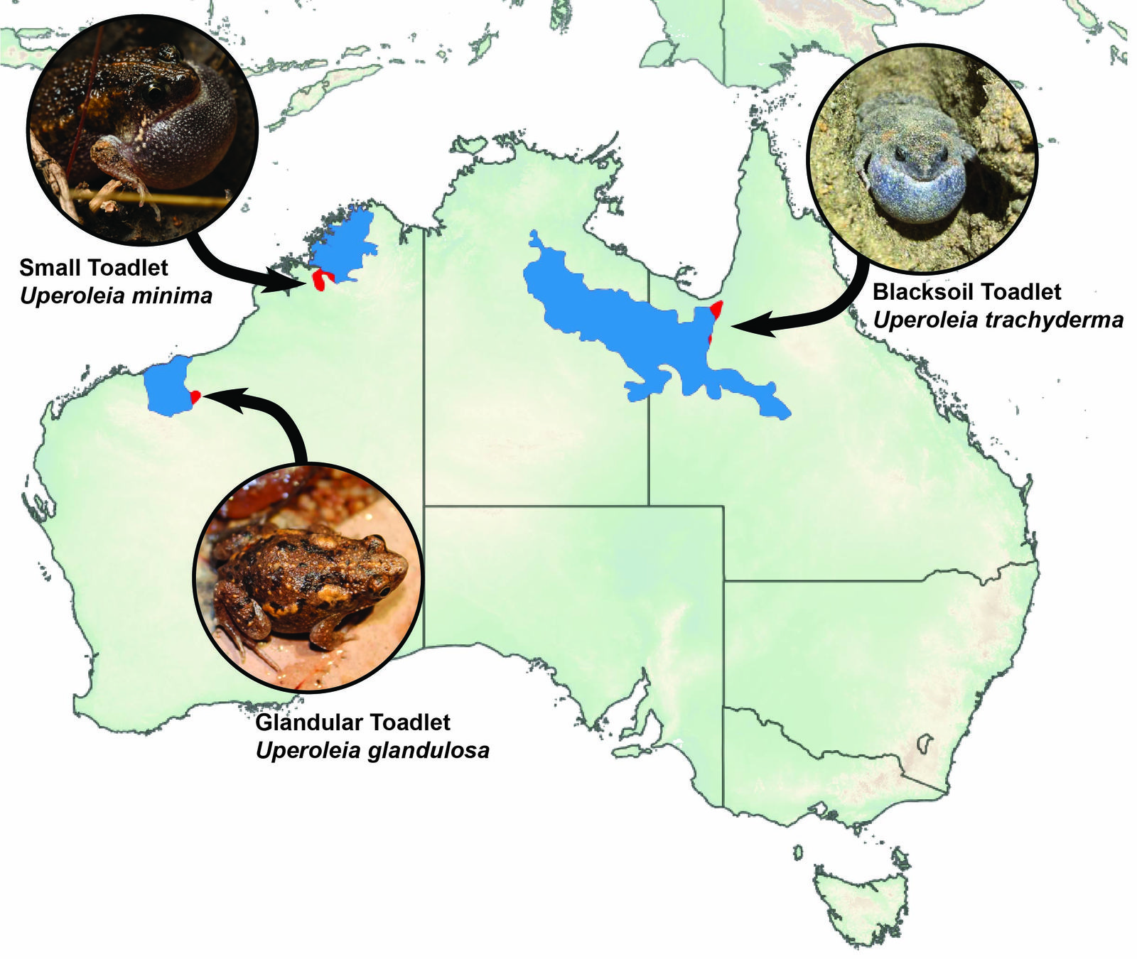
Version 4 of the Australian Frog Atlas has seen some major range extensions, including for the Small Toadlet (Uperoleia minima – inset: Ian Bool), the Blacksoil Toadlet (Uperoleia trachyderma – inset: Bob Elliot), and the Glandular Toadlet (Uperoleia glandulosa – inset: Renee Catullo), with ranges from Version 3 in blue, and new range extension highlighted in red. Image: Jodi Rowley.
Image: Jodi Rowley© Australian Museum
What do we know about frogs?
As our knowledge of frogs improves on a continual basis, the number of species known to Western science and the scientific names we use are also rapidly changing. This past year has seen the formal description of two new frog species in Australia – the Gobakula Frog (Callulops gobakula), and Koeypad Frog (Choerophryne koeypad) - and we are excited to introduce the range maps of these species to the Atlas. In addition, a 2025 study of the tree frogs of Australia and New Guinea has seen changes to the scientific names of 74 species, including the addition of 20 new genera. With these changes incorporated, Version 4 of the Australian Frog Atlas now includes detailed distribution maps for 260 species of frogs, including the introduced Cane Toad (Rhinella marina).
The latest version of the Atlas has seen changes to both species’ distribution ranges, and the data that we provide within the files. For the first time, we’ve indicated established populations outside of native ranges on the maps, as seen in some of our ‘hitchhiker’ species, such as the Eastern Dwarf Tree Frog (Drymomantis fallax), and Graceful Tree Frog (Chlorohyla gracilenta). Following on from public requests on how to improve the general usability of the Atlas, we’ve also incorporated the common name used by FrogID as an additional field in the shapefiles and KMLs.
Explore more!
The updated version of the Australian Frog Atlas is available to download as an Open Access resource. These publicly available resources include detailed shapefiles, KMLs simplified for more intuitive visualisation in Google Earth, and a map of species richness across Australia. As thousands of people across Australia continue to submit recordings to the FrogID app, our understanding of frog distributions is rapidly improving, helping in the effort to conserve some of our most threatened and unique species.
Acknowledgements
We would like to thank the Citizen Science Grants of the Australian Government and the Impact Grants program of IBM Australia for providing funding and resources to help build the initial FrogID App; the generous donors who have provided funding for the project; the Museum and Art Gallery of the Northern Territory, Queensland Museum, South Australian Museum, Tasmanian Museum and Art Gallery, and Western Australian Museum as FrogID partner museums; the many Australian Museum staff and volunteers who make up the FrogID team; and, most importantly, the thousands of citizen scientists across Australia who have volunteered their time to record frog calls with FrogID.
More information
- Australian Frog Atlas 4.0, https://zenodo.org/records/21404590
- Cutajar, T.P., Portway, C.D., Gillard, G.L., and Rowley, J.J.L. (2022) Australian Frog Atlas: Species’ distribution maps informed by the FrogID Dataset. Technical Reports of the Australian Museum, Online 36: 1-48. https://doi.org/10.3853/j.1835-4211.36.2022.1789.
